(This expedition won the IMF Award for "Outstanding Exploratory Civilian Expedition" in 2014)
Traversing the Chunsa Khaga
>>>>>>>>>>>>>>>>Continued from Part II
>>>>>>>>>>>>>>>>
Stage II- Snow Trudge through Glacier Kingdom
Kalapani 4350M- Base Camp 4950M (6 Km)- Advanced Base Camp
5250 M(2.5 km)- Chunsa Khaga 5500M (1.5 Km) -Baspa Glacier 5000 M(5 Km)-
Gaundar 4250M (14 Km)
 |
| (Route ahead of Kalapani Camp on right moraine) |
We made rapid progress next day along the right lateral
moraine. After about a kilometer we entered the massive glacial
amphitheater of the Kalapani glacier
at the middle of which gurgled the baby stream of Kalapani Nala (Bushaheri Nala as Tilak would say). Getting into the amphitheater required some step cutting to ensure safety for the laden porters.
Though there was no crevasse danger in the area, the snow covered boulders made our progress rather slow.
 |
| (Exposed slope before entry to main Kalapani Glacier area) |
Though there was no crevasse danger in the area, the snow covered boulders made our progress rather slow.
Crossing the Busheheri
Nala required only a hop-over. Though the stream currently looked quite
innocent, at some point in time it must have carried enormous power. As we had
observed the previous day, just a couple of kilometers from where we stood now,
this little river has gouged out a relatively new looking gorge almost 300 feet deep,
right through the middle of the glacial fan of Kalapani.
 |
| (The snow trudge on Kalapani Glacier) |
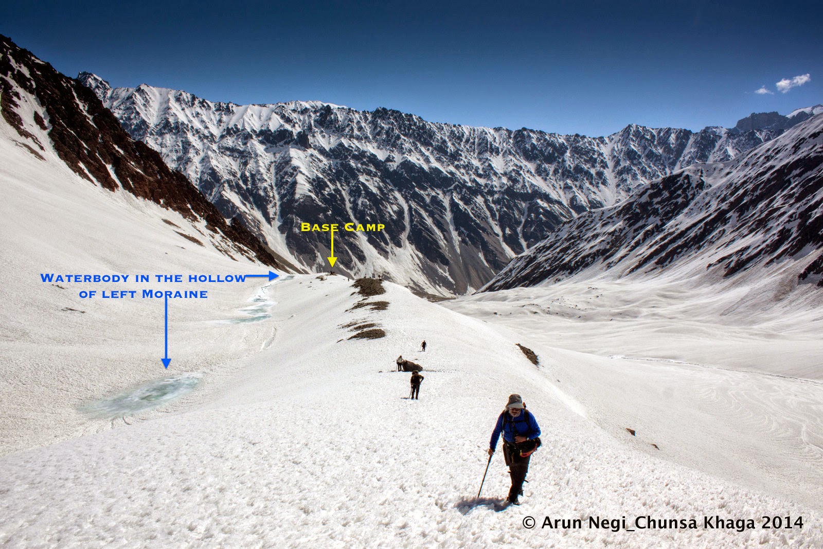
The progress was slow yet steady through the ever rising,
steep and virgin snow slopes on the left bank of the Nala. In another hour we gained the tabletop of the left lateral
moraine of the Kalapani glacier. As
expected a small blue tarn greeted us at
the entrance to the table top. We had noticed this tarn earlier in the Sat-recee.
Located at the very end of the left lateral moraine, it is
almost a permanent water body that collects snow-melt from the glacier on the
plateau above all year round.
 |
| (Base Camp at beginning of the left moraine) |
We had found our Base
Camp. With fully laden porters, we had managed the 6 Km trudge and the
altitude gain of 600 Meters in just over 4 Hours.The weather turned for the worse as soon as we pitched camp
and remained so till about midnight.
A bright morning next day beaconed us to
move station to the Advance Base Camp,
which we had planned to have at the head of the lateral moraine and at the foot
of the pass.
 |
| (The steady ascent up the left moraine) |
Even though we were a short scramble of three kilometers
away from the Advanced Base Camp, we
had not yet had a glimpse of our objective. We were just pushing on blindly
following GPS and the landmarks.
After about an hour of steady climb on the lateral moraine
ridge we came to the head of it where it merged into a minor buttress coming
out of the bounding ridge to our right. The left moraine thinned out into a bottleneck at this point as visible from a distance.
 |
| (Looking towards head of the valley on the way up) |
We had no option but to go over it following a steep zigzag
across an exposed slope of virgin snow. Another hour and half a kilometer of
frustrating climb later, we finally gained the top of the buttress; a huge
convex hilltop. Right ahead to the West was
the Chunsa Khaga. Its twin sister,
the Chunsa Khaga (South) was nestled prettily to its left
beyond a rocky pinnacle.
 |
| (Route ahead to ABC at end of moraine) |
Technology had
delivered yet again. We had almost blindly navigated through the whole of the Upper Chor Gad and Kalapani valleys, our only eyes being the Garmin handheld, and here we were standing right at the feet of a
rather friendly looking objective! We were seeing it for the first time even as we
almost emerged from under its little toe!!
 |
| (ABC on the convex hilltop at base of the Pass) |
The weather predictions had been correct, the terrain
monitors had been correct, the sat images and landmarks had been correct and
the GPS had tracked geo-data with absolute accuracy in all weather conditions. These were signs that the mountain was in a
mood to let us in.
What all would the likes of Gerard, Hodgson, Herbert, Shipton
and Tillman have achieved if they would have had access to such mind-numbing
technologies?! I reflected for a moment. It was a humbling thought.
 |
| (Finally! The Chunsa Khaga shows up) |
That evening we set up the prayer flag that the Old Jadh at Uttarkashi had handed over to us. Negi, Nitin and few others laboriously secured anchors for the flag
and set it up upon a conspicuous hollow with a steady traffic of wind. It felt nice,
keeping our promise to the old man.
The scene around was surreal. Giant 6000ers of the Nelang and adjoining valleys dotted the
east and southeast horizon. Pk Nakurche
(6010M), our objective of the previous year, dominated the skyline being
the closest. Towards the west, the twin passes of Chunsa Khaga North and South were
looking glorious, their surfaces shining a metallic
gold as the snow-melt deflected the setting sun.
 |
| (Keeping the promise made to the Jadh Bhotia at Uttarkashi) |
As soon as the sun went down the moon shone bright but the
intense cold drew us into the warmth of the sleeping bag.
Sleep was not easy in all that cold and anxiety….
The pass had yet to be crossed and the descent on the other
side was still an unknown factor. But the weather was good and the spirits were
fine. “In any case we should be able to handle a technical descent if push came
to a shove”… I went to sleep ruminating
over all different permutations of possibilities.
>>>>>>>>>
 |
| (Started off from ABC- long trudge to the top) |
The ascent to the pass involves a sharp climb first till a place where the Kalapani North Glacier takes a sharp tumble down. Then
the ascent tapers off to an easy gradient. This inflection point where the
gradients change was an important part of our route plan since this is where we
expected the few crevasses on this side of the pass. Thankfully the potential
danger areas were well marked on the GPS and visually confirmed the previous
day.
 |
| (Actual GPS Plot of the ascent - Sat Imagery of Sept 2013 with easier snow conditions) |
We thus planned a route keeping close to the left of the
glacier at the foot of the bounding ridge to north. Near the point of
inflection we steered diagonally to the middle of the glacier so as to avoid
potential crevasses. Ahead was an easy incline along a valley-trough about half
a kilometer wide.
A small cloud cluster emerged over the dip in the ridgeline
ahead clearly demarcating the pass saddle. For a moment my mind wandered off to
a fleeting visual of a packed caravan of royal soldiers heading down from that
top – dressed in thick woollens and leading down a train of Yaks.
 |
| (Little crown of cloud over the saddle) |
“That’s how it would have looked like in those days. Would
they be looking spirited or saggy? Would they be freebooters looking forward to adventure and plunder or just duty-bound employees“. I was trying to keep my mind busy recreating the
romance of a bygone era, perhaps to avoid focusing on the toil that was taking
my breath out easily every few steps. Before long we reached the top of the
saddle.
 |
| (The final ascent to the top- entering mid glacier area) |
Within about two hours of the commencement of the climb, the
entire team was atop the Chunsa Khaga-5500M;
just under 18000 ft (17900ft to be precise) as described by all previous
accounts. We had made good time and still had at least 2 to 3 hours of walk
left before the unstable afternoon weathers of the extreme altitudes start
threatening our plans. The route looked good for the 5 Kms of descent coming up ahead
through the snowfield. We could already see a bad patch of gaping crevasses about
a kilometer away. It didn't look too big.
 |
| (Sprawling panorama of Baspa Glacier from atop the Chunsa Khaga, Old Joshi getting ready to do 'pooja' of the newly built cairn) |
From where we came, the Mt
Nakurche shone bright on the horizon bidding us adieu. Farther one could
make out the faint outlines of Sri
Kailash and Kamet. As we looked
ahead across the saddle of the pass we could see the sprawling expanse of the Head of the Baspa Glacier. The complex
knot of ridges of the Gundar and Arsomang tributaries of the glacier were
directly ahead and the westerly flow of the wide glacier was visible for at
least five miles.
 |
| (Team with Tricolor atop the Pass L to R- Ashu, Arun, Vinod, Sanjit, Bharat, Venkat- Nitin on camera) |
“उतराई ठीक है Sir”
said Vinod coming up from below the
brown ridge on the far side of the saddle. He had finished the initial
reconnaissance for the descent as the team slowly regrouped at the summit
point. We had set up a large cairn on the brow of the brown patch of rocks that
defined the Baspa end of the saddle.
The little ridge we were standing on was actually the beginning of the 10-mile
long East-West
ridge that acted as the division of the water partings between Baspa and its neighboring valleys to the
south.
It was interesting to observe that the waters of the Chor Gad joined the Bay of Bengal whereas the waters of the Baspa eventually joined the Arabian Sea. The bed of
virgin white snows on each side of declivity of the saddle were going to send
out their waters to destinations that were going to be spaced apart by the
entire width of the Indian sub-continent.
 |
| (Roped descent into the Baspa through crevassed field) |
The descent was not as difficult as we expected immediately
after the pass. About a kilometer later we could sense a change in the profile
of the glacier bed indicating imminent danger of crevasses. The team got
organized into two ropes and followed a rib to the flat snowfields of the
glacier down below. A couple of sinister looking glacial tarns with
greenish-blue waters passed us by on both sides. The sun was beating down
mercilessly and the ambient temperatures read a high 44deg Celsius!
After another hour we un-roped having reached stable
grounds. After 5 kilometers of traverse from the pass we finally reached the
place where the Glacier bends away in a northwesterly direction. The waypoint
on my GPS read “Baspa Glacier Bend”!
 |
| (Baspa Gl Camp- Tributary glacier in background. tarn just beyond the dark tent in extreme right) |
A little tarn was located nearby where a tributary glacier
joined in from the true right of the Baspa
headwaters. The glow of the setting sun upon that sloping tributary glacier
created the perfect dreamy canvas for the camping of the triumphant team.
We had pushed non-stop for the past 6 days and here we were
past the biggest objective and obstacle. Only one last bit remained- that of
traversing the length of the uncharted Baspa
glacier with its steep avalanche prone sides, without any incident.
Panorama at the head of the Baspa Glacier
Panorama at the head of the Baspa Glacier
>>>>>>>>>>>>>>>>>>
Stage III- Out of the mountains along The Baspa
>>>>>>>>>>>>>>>>>>
Gaundar CG 4250M- Nithal 4200M(6 Km)- Dumti CG 4000 M (10
Km)- Ranikanda 3700M (12 Km)- Nagasthi 3500M (6 Km)- Chitkul 3400M(3 Km)- Delhi
(500 Km Drive)
 |
| (Leaving behind Baspa camp, stream from the camp tarn flows on left) |
While designing the route we knew that the right bank of Baspa Glacier was our safest bet for it
had the longest unbroken surface, almost till one reached the snout of the
glacier. In contrast, the left side was not only close to avalanche prone sides
but also was heavily broken for the last 2 kilometers of the glacier’s length.
Also the right bank being a south facing side was likely to be more free from
snow than the left. After 3 full days in snow we were itching to get back to
normal grounds.
 |
| (Baby Baspa- 2 Kms from the camp site, 12 Kms to go to the snout!) |
About a hundred meters from the camp we saw the beginning of
the little stream of Baspa, which
slowly but steadily increased in its girth as we walked along. It went
subterranean after a while where the mile long prominent medial moraine became
visible. Within about 3 hours of our march we could see the outline of the Lamkhaga ridge junction indicating that
the snout area was coming near.
 |
| (Beginning of the long medial moraine of Baspa The course of Baspa stream to its right) |
In the last 2 kilometers we could see the death throes of
the Baspa Glacier as massive patches
of open and broken glacier surfaces revealed the flow of Baspa beneath it. We could see the river fully exposed at least two
kilometers above what is formally known as the snout of the glacier. In the
last one kilometer or so it looked like a row of massive broken ice slabs
standing in reverence on the two sides as the proud Baspa flowed in the middle in her erratic and confounding course.
The day the two transverse ice barriers defining the snout
melt away, the source of Baspa will suddenly recede by at least half a
kilometer in one stroke!
 |
| (The broken terminal moraine area of Baspa Gl It took us 3 hrs to reach the snout area from here) |
After the 14 Km long trudge over snow, rock and boulders we
reached the snout around 1500 Hrs. A kilometer ahead was the Gaundar camping grounds; our objective
for the day.
The dry shrubs of the area allowed us a modest but nice camp
fire that lasted late into the night. We were a relieved bunch having blazed
our way through the icy regions in a single push without using any resting
time.
The last challenges of the Baspa valley remained to be tackled now- the swollen rivers all the
way and the exposed slopes between Dumti and
Ranikanda. Our immediate concerns
were the two sizeable streams that were to be forded the next day- first the Gaundar Nala and then the bigger and
more tempestuous Arsomang Nala. Beyond
that lay the Nithal ITBP post- the
deepest post in the Baspa valley and
the first that we were to see on our way down.
>>>>>>>>>>>>>>>
Thankfully a snow bridge over Gaundar Nala and a well-engineered bridge over the Arsomang Nala saw us through to Nithal Post in no time. Twenty odd men
from the Army and ITBP greeted us on the high right bank
of Baspa.
 |
| (With Jawans at ITBP-Nithal First human habitation after 8 days) |
The post staffing was relatively thin since a large detachment
of troops had left for military-exercise near the Yamrang La, we were told. After the paperwork and reporting we had
the customary photo-op with the jawans before
we left for the ten kilometers of onward march to Dumti post.
The river bed fans out wide after the Nithal post, the distance between the two banks gradually
increasing to about two kilometers very soon.
The massive flat in between is filled with grass, shrubs and rocks. Numerous springs emerge here on the riverbed and combine to form the clear blue waters of the Nithal Nadi, which merges with the Baspa with in about a kilometer.
 |
| (Wide expanse of Sunthi meadows ahead of Nithal) |
The massive flat in between is filled with grass, shrubs and rocks. Numerous springs emerge here on the riverbed and combine to form the clear blue waters of the Nithal Nadi, which merges with the Baspa with in about a kilometer.
Before long we crossed the green meadows heralding the
approach of Dumti as the Baspa narrowed down again before taking
a giant sweeping turn to skirt the remains of a long dead glacial fan coming
down from the Rangrik Rang massif.
Upon this flat glacial fan the Dumti
post is located.
 |
| (Walking along the Nithal Nadi en route Dumti) |
Across a stream we saw a small group of people who seemed to
be waiting for us. It looked like we had a welcome party from the ITBP ready
with ‘chai’ refreshments (tea and
biscuits). Nearby was the Karu Devta temple
– the presiding deity of the Dumti area.
Legend goes that once Fredrick
Wilson of Harsil had travelled to
Dumti around circa 1881 and here he
fell seriously ill[i]. A
goat then had to be offered to Karu Devta
before he instantly recovered- writes S
J Stone in his 1891 memoir[ii].
“बकरीवाले इधर से आगे जाने से पहले बलि चढ़ाते हैं”
 |
| (The very old Karu Devta temple in the shadows of Rangrik Rang) |
“श्रद्धा की बात है जी. उनकी पार्टी भी हो जाती है शायद” replied the senior looking tall man in the welcome party with a
heavy Haryanvi accent.
Looked like Karu Devta
had pretty sanguine tastes and everyone seemed to be convinced about the
morality of it.
We had a reasonably high-powered welcome committee
comprising of the #1 and the #2 officers in-charge of the post, two very
amiable gentlemen full of stories of their exploits. They were the epitome of
hospitality during the next 18 Hours of our stay there.
 |
| (The commander of Dumti leading us towards the post) |
All the food that came our way from the Langar was hounded off swiftly.
The simple “dal- chawal- sabzi”
fare suddenly tasted amazingly delicious!
We
were evidently bored out of the repetitive taste of the camp kitchen. Dillip, the camp cook, did not look
very amused with our zesty enthusiasm.
 |
| (Chatting up with friends from ITBP- Dumti Guest House) |
During the idle discussions in the evening, the familiar
sadness of having to go back to the fleshpot of the city had begun welling up
inside. We were targeting a long march to Chitkul
next day; a gradual descent with couple of tricky patches over 21 kilometers. Some
of us grumbled a bit about the march but eventually came round to the fact that
there was no point camping in Ranikanda with
the road head of Chitkul just 2 hours
away.
<<<<<<<<<<<<<
 |
| (Tricky patch between Dumti and Ranikanda) |
Immediately after Dumti,
the trail winds along some exposed and broken slopes of loose scree, which
require extreme care. The view of the angry waters of the Baspa, foaming almost
vertically below, is not a comfortable sight.
About two kilometers before Ranikanda one crosses the craggy and exposed sides of mountain of
red-rocks, famously known as “Lal Dhang”-
The Red Hill. The rusting slabs on
the trail confirm our suspicion that it is actually a mountain of red hematite-
iron ore!
 |
| (The famous Lal Dhang area) |
Couple of ITBP Jawans were waiting with tea as we approached
the point where a bridge across the river leads one over to the left bank where
the Ranikanda post is located. The
post is at one end of a massive meadow that extends for about two miles
upstream.
As we approached the Doaria
CG, the lovely meadow on right bank opposite the valley coming from Borasu Pass, we saw a large number of
ITBP and Army men moving into the valley for exercise. Soldiers and shepherds
alike gave us the look of utter incredulity when we told them where we were
coming from.
 |
| (Soldiers moving in for exercise as we approach Doaria) |
“ हाँ चूंसा खागा! हमने भी सुना है. कैसा रास्ता है?”
said one of the Chitkul shepherds as
he fell into step with me on the winding trail from Doaria Meadows to Nagasthi.
After a final regrouping, refreshments and photo-op with
jawans of ITBP Nagasthi we set off
one our last leg to Chitkul. It was 1530, seven straight hours and 21
Kilometers of hard march out of Dumti,
when we reached the Chitkul Bus Stand.
********************
 |
| (Horses grazing at the lovely meadow of Doaria) |
The drive down to Sangla and then the long drive back to Delhi the next day, were largely uneventful. What I do remember vividly though is the spectacular course of the Satluj and the marvellous road engineering at the scary Taranda gorge on the drive down the district of Kinnaur.
The valley of Satluj is
spectacular and awe inspiring. Her torrents are way ferocious compared to the
fiercest form of the Ganga or the Yamuna. The volume, turbulence and
muddiness of her waters tell the story of her long descent from the arid Trans-Himlayas. I made a mental note for
future explorations along her valleys- perhaps The Tedong? Or the Gymthing
? The allure of many ancient trails, of Shimdong
La and Khimokul La, beacon
strong as I read more about this wild river.
Thus ended our third visit into the valley of the Jahnavi. Instead of satiating the thirst, this journey only deepened it further. The watershed with her many dimensions creates some sort of a magnetic pull. Whether the mighty mountain allows that foray into the last valleys of Tirpani and Nilapani will be seen in due course of time.
Thus ended our third visit into the valley of the Jahnavi. Instead of satiating the thirst, this journey only deepened it further. The watershed with her many dimensions creates some sort of a magnetic pull. Whether the mighty mountain allows that foray into the last valleys of Tirpani and Nilapani will be seen in due course of time.
4 comments:
Can you please share the route map. It was a fascinating read. I like to explore unknown valleys (on google maps till now) and was wondering whether NeLang and Baspa are connected and came across your blog. Would be great if you could plot the route on a google maps and share. Thanks in Advance
Hi thanks ...
you can see a overall map in the first of the Nelang Odysseys series
Auden's Trail -1
YET another fascinating expedition! Read it side by side an open instance of Google Earth. It would add to the reader's experience if you mention GPS coordinates of each of your campsites.
Can't wait for your next adventure!
Uday
Thankx Uday Thanx much for the compliments..yes hv put effort to provide enough details for a Google Earth fan...hope it has helped
Post a Comment