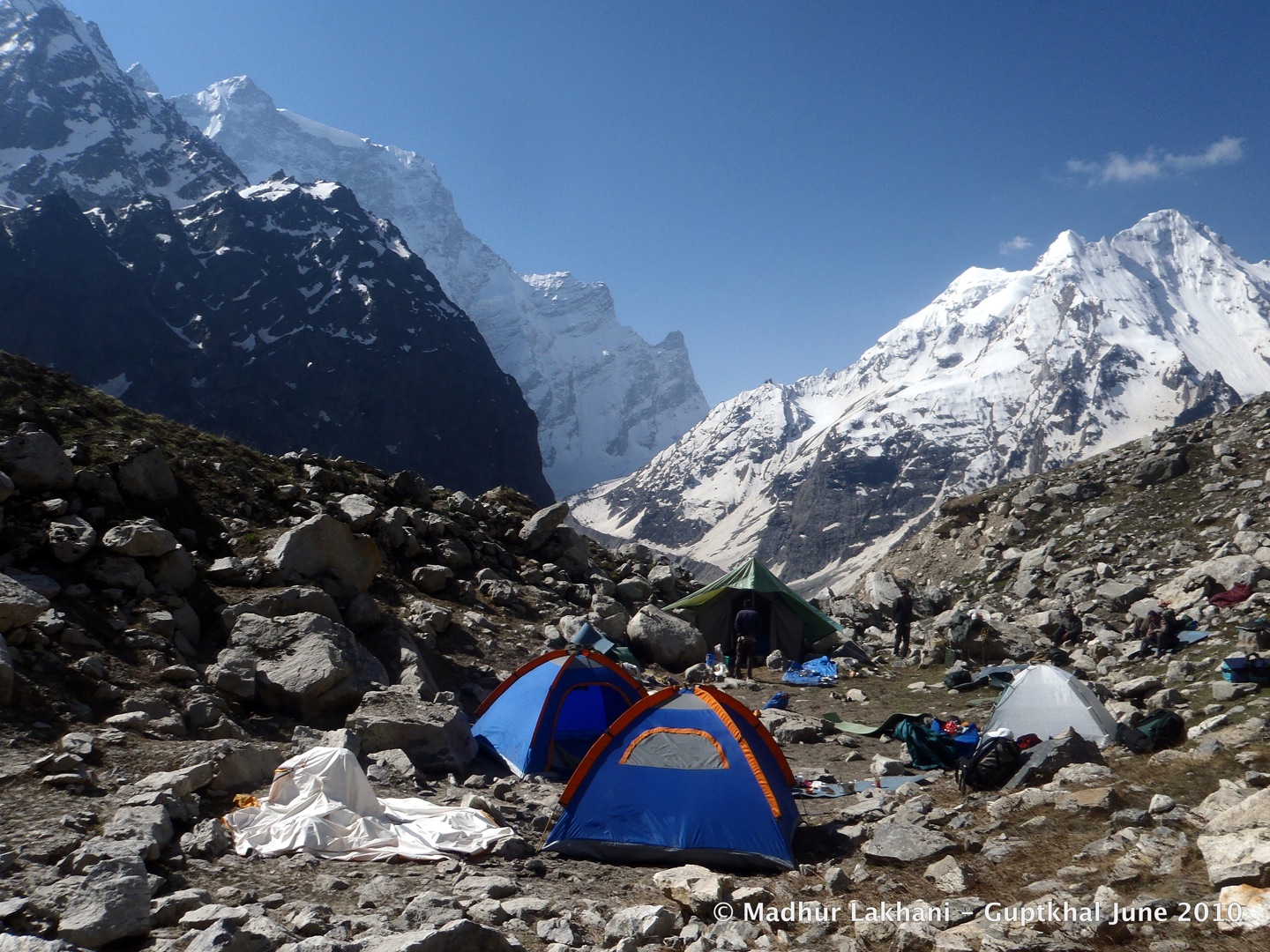
 |
| (Morning at Gupt Khal base after 20 Hrs of snowfall) |
"Shall we turn on the camp lantern?" Rajesh surprised me with a response from deep within his sleeping bag. "Its only 3 in the morning. Long hours yet for the light" He said.
"You know what? If this goes on like this for another day, we shall have 6 feet of snow outside. How will we even get out? " I was audibly worried as the LED lantern switched on.
Somewhere in the back of the mind there was a fervent wish to be out of that hole, back to the wide roads of Delhi again, back to family and friends.
 |
| (Mana icefall just behind base camp at Guptkhal) |
Just then there was a muffled rumble as another avalanche cascaded down from the Mana icefall few hundred meters away. I shuddered at the thought of a similar action from the ridge of Gupt-Khal much closer behind, barely a hundred yards away.
We were in our highest camp at 5700 Meters. I could feel the snow pressing against my back like a huge pillow as I tossed and turned inside the sleeping bag cloaked from top to bottom in Goose Down. The relative warmth of the tent measured at 8 degrees below freezing.
"Yesterday was colder still, at -15. At least its warmer today!"- I said as Rajesh nodded in agreement.
Tomorrow would be another day, hopefully a kinder one. We had lost the power to contemplate what the skies had in store for us. Every morning and evening had been a surprise for the past week and now we were there, at the base of the "Hidden Pass". The irony was, weather gods had chosen that night to unleash their full fury!
The pitter-patter of the snowfall slowly drew the shroud of slumber. Before long I was dreaming away, walking alone on a vast snowfield.
__________________________________________________________
The Beginning
 |
| (Frank Sydney Smythe- Die-hard Garhwal lover) |
Looking at the distant snowy peaks peeking behind the clouds, I could imagine a team of adventurers descending down and standing awestruck looking at the splendid colors of pink, crimson, magenta and the entire rainbow variously dotted on a velvety green carpet.
It was a moment of wild imagination and romance, which etched a mark in the young mind. In the August of 1992 I was on my second excursion to the mighty mountains yet. Frank Smythe was to remain a silhouette of a figure for years to come popping up every time there was a chance to discuss the magnificent garden of Eden in Garhwal- The Valley of Flowers.
 |
| (Smythe's 1937 exploration route) |
Thus began my personal search of journeys done 8 decades ago, deep into the valleys of Garhwal, into areas rarely seen by the human eye. What got me hooked was the journey Smythe did in 1937, lured back into the valley after his maiden visit in 1931. On that occasion he spent several weeks exploring the various peaks at Valley of Flowers, the Devban Plateau, The Zaskar Pass (Called Gupt Khal today) making several first ascents in the area.
We decided to follow his footsteps, to the extent possible in the limited 2 week window that modern day worklife permits. The idea of Expedition Eden2Heaven was born.
________________________________________________________________
The Team
After several nominations and screenings, opt-ins and dropouts at various discussion threads at Orkut.com and Indiamike.com, we finally converged. All doubts about the team ability and fitness were put to rest the moment we were all together. The conviction and bonding grew as the days passed and the challenges piled on.
It was a pleasure to lead a team as diverse yet as focused. We all vibed instantly in spite of there being three new members in the team- Suraj, Vishwa and Madhur. Each had something unique to contribute and each carried out the team instructions to the tee; perhaps the only group I had ever been with that displayed such alignment in fitness and performance.
 |
| ( L-R- Madhur, Bharat, Suraj, Rajesh, Ashu, Vishwa, Arun & Ravin) |
Madhur and Ravin were the keen listeners who would occasionally create bursts of laughter's with their rare wisecracks. Ravin, as usual was the silent wonder. All of us who had not seen him at work earlier would later admit total surprise at this compact and tenacious powerhouse who would always be ready to extend a helping hand. Madhur gracefully digested his utter shock at being close to such extreme altitudes of the mighty Mountain (he had never imagined it would be this big- he told us later). He however never let that surprise show and gallantly rose to the occasions.
Bharat and Arun – both hardy fighters showed their Fauji origins as usual. The young and handsome lads never flinched to take up a challenge, always helped out the porters and techies and carried extra loads where the situation demanded. Bharat would spice up the conversation with his usual banter about women and romance. Arun would be the diligent artist clicking away his new DSLR and dutifully logging daily tour data into his diary. Together, they are a formidable duo to have in any team.
Rajesh, being the senior-most among us would carry the coolest head (except for the horrendous descent through snowed-out boulders at Nakthani Glacier J). He was at his chirpiest best when we were in the deepest hole. I still remember the night, when I was sharing my concerns with him as it snowed relentlessly outside. He was a solid pillar of support and optimism. The one thing that any team needs at dire hours is a burst of energy, laughter and hope. He made sure we never ran short of that.
Complexity of this trek would have increased several folds, had it not been for the lucky composition of the team.
******************************************************************************************
Day 0- Delhi- Rishikesh (226 Kms- Drive)
Keeping one eye on the road I was listening to Rajesh - describing his chat with Meenal, his wife, in his characteristic way- bubbling with energy. We were driving down to Rishikesh on the late afternoon of 28th May.
"..and then she asked me 'why have you kept a name like this for the expedition?' and I told her-' Eden is like a synonym for Valley of Flower and Heaven denotes the great heights we shall touch at Gupt-Khal!'…..and she said- 'that's all fine .. but it sounds pretty weird. You should have at least added 'and back' to that name'"- and we both burst out laughing.
I laughed, but I had a moment of reflection. A silent prayer went out to the gods above.
It was late night when we reached at Dayanand Ashram at Rishikesh. The rest of the team would join us there at the break of the dawn.
******************************************************************************************
Day 1- Rishikesh- Josimath (280 Kms- Drive)
 |
| (The Ganges seen from Dayanand Ashram- Rishikesh) |
The anxiety to start early made us display stellar efficiency and we were ready for the day's drive at 0745 Hrs. In that duration Madhur joined in, the tyres got checked, the pollution certificate obtained, the breakfast done and the water bottles bought- all that in 45 minutes!
We made good speed, crossing Srinagar by 1200. Vishwa was in another vehicle with the 'Crystal' team, joining in from Uttarkashi. He had reached Uttarkashi the previous evening on his way down from Kedartaal.
By 1800 Hrs the entire team had assembled at Hotel Brahm Kamal- Joshimath.
The evening was spent unpacking and distributing all necessary equipment to members and porters. A quick check revealed that we were running short of good woolen socks and gloves.
Madhur seemed to have overlooked the emphatic remarks about woolens in the preparation checklist and Vishwa seemed to be harboring enormous trust on his body to withstand any possible cold. Somehow all agreed on the need for acquiring local knitwear handcrafted by the Bhotias of Mana Village. We went about searching for the shop.
Joshimath had transformed in 6 months time. When we visited last, during the trek to Kagbhushandi Taal, it had a quaint and colonial look- orderly, pretty and silent. Now, at the peak of the pilgrim-season it was a replica of any other urban wilderness! Big families from various corners of the country speaking various tongues, little groups of local youth chatting around, honking motor cars and buses all eager to go somewhere- it was Joshimath at its cosmopolitan best- or worst.
After a bit of asking around we located a little shanty of a shop near the bus-stand, which sold the woolen garments by weight! The shopkeeper used some crude mathematical formula to calculate the price based on the weight of the product. Roughly it came to about Rs 100 for a pair of warm socks and a similar price for a head-cover.
 |
| (The planned route ahead of Joshimath) |
Satisfied that we had fortified our resources, we hurried back to the hotel, eager to celebrate the arrival in the laps of the great mountains. The eagerness was amplified because we were not to see or touch alcohol for the next few weeks- not so much for spiritual reasons as for health related ones.
Vinod came back with the information late in the night about the permits being granted from both the Forest Department and the SDM's Office. The last obstacle being out of the way, I breathed a sigh of relief.
Tomorrow would see the beginning of a long walk. We all slept like logs after that long drive, making up for the lost slumber in the night before.
******************************************************************************************
Day 2 – Joshimath- Govind Ghat(1700M)(26 Km Drive)- Ghangharia (3100M)(13 Kms Trek)
Coming from the Kagbhushandi experience, we were anxious to start early from Joshimath. If that experience was anything to go by, we had to start the trek latest by 0900 Hrs to have any reasonable hope of camping at Ghangharia by sundown. The team responded well and we were at Govindghat by 0930 ready to hit the trail.
Everything around had changed. The ghost town that we saw in November was teeming with activity. Sikh pilgrims of all ages, sizes and sects were busily moving about. New shops were being setup in hope of the brisk business that was about to follow during the season. An unending stream of cars was pouring into the parking lots. The roadsides were lined with waiting cab drivers playing cards lazily. An occasional horse would saunter past with jingling bells and newly upholstered saddle.
We were able to start the trek at about 1000 Hrs with each member taking his own time to cross the start line- stepping into the bridge over Alakananda. As I looked down into the flowing mass of the water beneath, I was reminded of the oncoming monsoons. The color of the water was already a muddy brown- so unlike the turquoise one sees in autumn.
 |
| (Auspicious beginning) |
First came a man with a flag carrying the Khalsa symbol followed by five men carrying glinting swords raised upright- The Punj Pyaras. Behind them was a person carrying the holy book on his head. Behind him was a portly gentleman carrying a decorated sword and chanting the Khalsa Chant "Raj karega Khalsa- aaki rahe na koi".
We had just stumbled upon an auspicious beginning! We were witnessing the rituals that precede the opening of the Holy Sikh Shrine at Hemkund Sahib, which attracts thousands of Sikh pilgrims every year. The procession that started from Govindghat at 10 in the morning would proceed non-stop till it reached the shrine 19 Kms later and 2500 Meters higher, by the same evening! Some of our team members tried catching up with the procession, till they gave up a few kilometers later!
Soon we reached the Dhaba near Pulna village where numerous new smaller Dhabas had sprung up (compared to our last visit). While taking a breather in one of the Dhabas, a tired looking European turned up with two horses in his tow.
"यह अँगरेज़ दो घोड़ों के साथ पूरा चार धाम घूम रहा है sir" informed Shiv Singh, whom we lovingly called Bhotiaji.
It was an interesting sight- two horses, lightly loaded and followed by this gentleman almost in rags and a pair of slippers with matted blond locks.
Our amusement was short-lived for soon we heard an altercation going on between Mr Matted-Lock-2-Pony and the neighboring Dhaba-owner. Apparently someone had beaten the queue at the waterhole where Mr 2Pony was waiting to fill his water bottle. The Dhaba-wallah contested this version and insisted that its Mr 2Pony who was beating the queue.
 |
| (Mr 2Pony happily posing with Bharat) |
bottle and soon the chap was pacified.
"कहाँ गए थे Shiv Singh?" I asked when he returned.
"वो घोड़े वाला गोरा को पानी देने था Sir. झगड़ा हो रहा था वहां . पता नहीं शिव भगवन भी हो सकते हैं कोई भेष में . पानी देने से तो धरम ही होता है न Sir?"- Replied he, with brilliant innocence.
My heart filled with joy seeing the quintessential mountain-man. There is hope for humanity yet!
Soon we were off on the trail, trying to cross Bhyunder around lunchtime.
We were curiously shooting a purple looking fruit when an elderly gentleman stopped by watching us with great amusement. Seeing the friendly avuncular face we posed the query-
 |
| (Bekal- The ancient Himalayan oilseed) |
"यह कौन सा फल है जी ?"- we asked
"Bekal कहते हैं इससे "- Uncleji replied
"Bekal? कैसा होता है यह खाने मैं ?" – Bharat asked
"तेल निकलता है इससे. तेल मीठा होता है इसका - हम बचपन में खाते थे इसको रोटी के साथ - घी के माफिक होता है . लेकिन फल खाओ तो कड़वा है "- He replied.
The full team reunited for the first time at the Dhaba that overlooks the Haathi Parvat valley at Bhyunder village. All of us who were in the Kagbhushandi Taal team- Rajesh, Bharat, Arun and I, could not but help comparing the view we had seen last. What a contrast!
Gone were the brilliant shades of pastel on the forest and the azure blue of the skies. Instead, the valley now was a dull and deep green made duller by the grey clouds overhead. Didn't augur too well for the views ahead!
 |
| (Pulna Village in autumn-top and monsoon-bottom the village ceased to exist after 2013 flood) |
I stood transfixed for a moment watching a very active hive teeming with, probably, many thousands of bees. In a completely random way, patterns would appear on the surface of the hive and disappear in few seconds- natural fractal designs!
The route ahead led us through numerous twists and turns and moderate climbs. Before long we were looking at a meadow sprawled out in front with few Army-hutments and a helipad. We had reached the Kanjilla Camping Grounds- our target camp for the day. Ghangharia was still 600 Meters away, the GMVN signboard said.
Though it looks quite inviting for a camping ground, it can be a bit of a pain to find an easy water source at Kanjilla. After a bit of scouting around we ended up at the Army camp- seeking permission to use the water tap in their compound. The friendly Jawans readily acquiesced.
 |
| (Kanjilla camp- Bhyunder gorge at centre frame) |
Up ahead onto the northwest, the two lofty pinnacles of Bhyunder Gorge, became a dark outline as the sun went down. Beyond that imposing gateway was our target for the next day- the Garden of Eden- the Valley of Flowers.
******************************************************************************************
Day 3- Ghangharia(3100M)- Tipra Kharak Camping Grounds(3700M)(10 Kms Trek)
It was going to be my second visit to the Valley of Flowers in twenty years. The excitement that morning was not so much about seeing it again, but more about seeing for myself what would have changed in 2 decades? Now-a-days one sees surprising amount of changes in the Himalayas in that kind of a time period. The landscape, flora, fauna, forest cover, habitation and cleanliness – virtually everything in the Himalayas seems to be on a fast-forward to deterioration.
 |
| (Ghangharia pretty after so many changes!) |
The place where we had lazily spent the evening photographing the million stars above was now replaced with a bustling pony stand. The stench of mule-dung had now replaced the sweet smell of wild flowers. The massive mass of ice that greeted the pilgrims at the beginning of the Hemkund climb, in the August of 1992, was now a trickling waterfall.
We regrouped before "Forest Check Gate" that defines the entry point to the "Valley of Flowers". We wished to present ourselves at the entry-point as a single unit with all the necessary documents that had been so painfully obtained the previous night at Joshimath.
 |
| (At VoF Checkgate where permit is checked to allow camping) |
We were on our own now! We would now proceed deep into the valley, away from the hustle-bustle of the pilgrim route. No cell-phones, no more people! We would have to fend for ourselves and for each other. The flowers, the meadows, the snows and the stars would be our companions for the next 2 weeks.
So we proceeded forth aiming at the Bhyunder Gorge visible directly ahead, a silent prayer on the lips for good weather and eager hearts thumping with anxiety.
The Valley of Flowers is usually devoid of any flowers at this time of the year. Little clumps of bushes with dense bunches of buds were indicating the beauty that was about to be on display in a month's time; but not yet!
 |
| (View of Bhyunder Khal area on left shoulder of Rataban-W A minor pinnacle of main Rataban Peak) |
"Two days hence we shall be walking on that snow ridge"- I remember musing to myself.
After a few hundred meters the trail took a sharp bend towards the right, almost at a right angle at the Bamanidaur bend. From this point one could see the entire 5 Kms length of the valley stretching eastwards all the way till Tipra Kharak, almost touching the feet of the Rataban Peak.
 |
| (The sharp turn and view at Bamanidaur Grounds) |
 |
| (The entire walk till Tipra from Bamanidaur) |
A gently undulating and meandering trail leads from Bamanidaur Bend to the Tipra Kharak area. The 300m rise of elevation is so gentle that one barely notices it. At the peak of the monsoon season, it would perhaps be one of the most colorful 5-Km-walks on earth.
At the end of the valley the trail descends almost on to the river bed- the bed of River Pushpawati (Sanskrit for 'Flower Bearing'- very apt name indeed).
 |
| (Tipra camp being setup- Khunt Khal at centre frame) |
Suraj went off to meet his friends at the Researchers' camp, pitched few hundred meters ahead near the Tipra Glacier snout. When the night had descended and we were through with our initial chatter around the campfire we realized his absence. After frantic radio calls he reported his arrival at the camp around 2000 Hrs, duly escorted by his friends from the neighboring camp.
 |
| (Tipra Glacier area seen from Tipra Camp) |
This discussion about wildlife must have impacted us subconsciouly. All of us had various accounts of bear-vision and bear-sounds to narrate about, the next morning.
***********************************************************************************************
Day 4- Tipra Kharak (3700M)- Bhyunder Icefall Camp(4300M) ( 6 Kms Trek)
Day 4- Tipra Kharak (3700M)- Bhyunder Icefall Camp(4300M) ( 6 Kms Trek)
It was easy to loose track of time marveling at the bounty of beauty all around in the lazy morning the next day. The natural colors of the skies and the meadows were amplified several fold by the rays of a glorious sun.
 |
| (Morning at Tipra Camp) |
When it was time to start the trek, we noticed that Suraj had vanished again to meet his friends in the neighboring camp. We wondered for a moment if there was a special cause for his frequent visits there, someone of the fairer sex present in that camp perhaps? (All such ideas were quickly dispelled when we met his fellow researcher, Virender Rana :-)- Nice guy. He came with our party all the way till the end of the day's trek and helped scout for a suitable campsite before starting back for his own camp alone at 1600 Hrs!!).
 |
| (Route ahead from Tipra .. straight up and to the left) |
The route from Tipra Camp follows on the right-lateral moraine of the glacier. The moraine ridge is set pretty high above the glacier floor. Obviously this presented a much friendlier route than we might have encountered, had we forded our path on the glacier floor.
We had a broad idea about the route ahead. We had to reach the point where the Rataban Glacier coming in from North meets the Tipra Glacier. From then on we were to follow the left bank of Rataban in a Northerly direction till we encountered the Bhyunder Icefall.
 |
| (Location of lunchsite near confluence) |
The apparent increase in energy levels after the lunch was quickly neutralized as we steadily gained altitude on a highly exposed grassy slope. The Ghori Glacier (the other branch that forms the Tipra Glacier) was looking eerie behind us, under the fast-gathering afternoon clouds. The Rataban peak appeared ever closer and the finer features of the massive mountain soon became visible.
 |
| (First view of Bhyunder Icefall) |
A campsite was located on the moraine ridge beside a small rivulet of ice melt. The Bhyunder Icefall was directly in front. We slept at 4300 Mtrs in our 3rd night into the trek. Thankfully all of us were beginning to acclimatize pretty fast.
In the night, I did feel a deep sound coming from the ground around. "I must be dreaming of bears" I smiled to myself and went to sleep.
***********************************************************************************
Day 5- Bhyunder Icefall Camp(4300M)-Bhyunder Khal Base(4600M)(4Km Trek)
A moderate commotion outside the tent woke me up in the morning.
" Raat ko pura pahad gir pada udhar. Bahut saara pathar gira. Humen nind hi nahin aayi" – Prem Bahadur was describing animatedly and many of his colleagues were vigorously nodding their head to indicate their approval. Rajesh was eagerly absorbing the narrative while asking further details.
 |
| (Glorious morning at Icefall camp) |
This is a strange ventriloquy of the mountains, probably facilitated by typical terrains. The acoustics acts in such a way that one perceives the direction of the sound source to be exactly opposite to where it's actually emanating from. Somehow, these effects are more pronounced for such colossal events as an avalanche or serac-fall; causing much anxiety to the mind of the hapless listener.
(I had personally experienced such an event few years back at the Bhoj Kharak camp on the way to Kedar Taal. The incessant rock falls that happened through out the night on the opposite bank of the Kedar Ganga appeared to be happening right atop our little tent. I could not sleep the entire night on that occasion.)
The anxiety amongst Prem Bahadur and his friends was understandable.
Little did we know that it was just the beginning of a series of events that we were to witness in the days to come; such events, where the Mountain would assert its might and remind us of our puniness comprehensively.
 |
| (Route from Icefall camp to Bhyunder Khal Base camp) |
Our target was a raised platform near the rock-buttresses that fell from the tall ridge connecting the Rataban and Nilgiri massifs. We estimated, it would provide us with several advantages- the distance to be traveled on the "Pass-Day" would be shorter by 4 Kms and the vertical height to be gained would be lesser by 400 Meters.
 |
| (Descent to the glacier bed from Icefall camp) |
It was an easy walk on the glacier. Surrounded by tall glistening summits as one looked up and sneaky crevasses that appeared with surprising regularity as one looked down. Massive ice-slabs, almost five storey's high, blocked the way towards the North where lay the Nilgiri Icefall. A small rivulet was flowing in from that area and vanished into a large crevasse just below the slabs.
Soon we were walking close to the feet of the Bhyunder Icefall that had been dominating our view for an entire day. We were so close; we could feel its air on our cheeks. We were just about 300 meters away! There was enough evidence of the constant glacial activity at the bottom of the icefall in form of scattered debris and broken pieces of ice-blocks. Some of them were probably fresh from the previous night's event.
 |
| (On right bank of Icefall) |
Almost at touching distance of the icefall, on the high moraine bank, there is a lovely campsite. However, lack of a steady water source and the lure of gaining some height for the next day's toil forced us to proceed higher onwards.
 |
| (Bhyunder Khal bse camp- The Balcony Camp) |
It provided a 360-degree view of the panorama around.
The Nilgiri to the north, The VoF and Tipra Glacier to the south, The
Khuliaghata ridge to the west and the Bhyunder Icefall to the east.
 |
| (Nilgiri Parvat -southface from Bhyunder Base) |
The next day was going to be tough. Bhyunder-Khal had already claimed lives in the past. There were going to be crevasses on the other side of the pass and Bhotiaji, the only man in our team who had crossed the pass 14 years earlier was unsure as ever about the route. Putting all my faith on the tiny handheld GPS device and the God above, I went to sleep.
*******************************************************************************
Day 6- Bhyunder Base(4600M)- Bhyunder Khal(5100M)- Rataban(E) Glacier(4500M)(8Kms Trek)
There wasn't the usual excitement about the Pass-Day, the next morning. I think, everyone was quietly preparing for a personal challenge. Probably the display of power of nature was weighing down upon our minds- the highly capricious mood of the weather, the formidable presence of icefalls close-by, the stories of the fatalities en-route and the towering presence of White Mountains around.
 |
| (Sharp ascent up the slope to Bhyunder Khal) |
At about 4900 Meters, the view opened wide as we reached a snow plateau. A track through that virgin whiteness led east towards Rataban. We wondered for a moment, whose track could it be there? We had not heard of another party crossing before us that season.
"Bharal ya snow-fox hoga Sir"- Jaisingh concluded.
 |
| (Plateau on top of the slope leading east and then north) |
It was a tricky traverse with some areas clearly marked with rock-falls from above and the slope falling at an alarming angle to our right. Few hundred feet below lay an ice field that fed the Bhyunder Icefall, with pretty undulations and gaping crevasses here and there.
After a few hundred meters, the route takes a northerly turn and one can see a prominent depression directly ahead. The GPS pointed straight towards this depression.
 |
| (Last 15 minutes to Bhyunder Khal) |
It was an interesting coincidence. We reached the top of the Pass at 1240 Hr to see a complete whiteout on the other side. At 1242 Hrs, a wind hit us that began to increase speed with furious rapidity. Soon the pregnant clouds started precipitating and one could hear loud thunderclaps that appeared to be hitting the very ridges we were standing upon. We were in the midst of a blizzard. The altitude read 5092 Meters.
 |
| (Bhyunder Khal-5100M as the blizzard closes in) |
"God! It's the monsoons- the South-West Monsoon! " I said. Bharat and Arun nodded silently, all trying to shield from the winds and the blinding snow. It took us a while to realize our foolish act; Instead of finding our way down, we were huddled together at a point from where the wind was at its fiercest!
Jaisingh was shouting frantically in the radio- "वहां क्या रहे हो Sir? जल्दी से निचे उतरो .मेरा track बना हुआ है . उसी को पकड़ के धीरे धीरे निचे आ जाओ. Track मत छोड़ना ."
The wind slowed for a moment allowing us the window to get back into action. We started for the snowfield below. The porters were following in a long single file- the hoods of their jackets flailing about in the wind.
"क्या हुआ Bhotiaji?" I asked as I saw our formation coming to an abrupt halt. Bhotia had reached there earlier. For now, he was brooding deep contemplating the way ahead.
"Crevasse है आगे Sir" He said trying to peer through the whiteout.
"Route left को काटो … crevasse है तो icefall भी होगा "- I said. I vaguely remembered the Google Earth picture of the area. Had I checked the GPS at that moment, I would have realized that we were almost on top of the icefall.
"ठीक है Sir. अभी rope-up हो के चलेंगे . आगे और भी crevasse हो सकता है ". Jaisingh added.
 |
| (Relief after the roped traverse in blizzard and crevasses) |
"Hopefully we have passed this test of yours," I said silently looking at the grim looking pass, now appearing comparatively brighter.
We had trekked for almost six hours and the water supplies were woefully low. I doubted if we had the strength and the morale to cross another six kilometers to Bank-kund lake camp before sundown. The weather did not help either.
 |
| (Rataban Gl campsite after descent) |
Far ahead was a bounding ridge with lofty peaks and hanging glaciers barely visible behind veils of clouds. We could see the Thur Udyar route to Devban Plateau that Smythe describes. It looked like a paved road leading skywards. The craft of the celestial sculptor was spellbinding.
XXXXXXXXX>>>>>>>>>>>>>>>>>>>>>>>>>>>>>>>>>>>>>>>>>>>>>>>XXXXXXXXXX
To be continued in Part II
18 comments:
Excellent blog to read and enjoy thoroughly...lovely pics...thanks a lot, Ashu, for sharing with all of us who are not able to make it...
Thanks Urvashi.. thanks much for encouraging with the kind words.
I keenly follow ur post and enjoy a lot. Strangely enough we have an association at Kolkata named HIMAPATHIK !! Thanks..
Thanks Santanu for the appreciation. Thanks :-)
I suggest you invest in some alpine harnesses... A crevasse fall with a rope tied around your waist could cause a spine to break, or the rope to slip up to your neck. It would not only make recovery useless, but it could endanger the others trying to pull out the injured person.
Happy mountaineering!
Hi Anonymous
Thanks for the suggestion. Thankfully we have evolved since continuously I believe, in terms of equipment and preparedness with each subsequent trek as each route presented a new challenge. Also it helped to keep an additional objective of a peak climb which mandates certain equipment in your inventory.
It certainly has helped.
this trek is something that I wanted to do always, sir, will you please mention the cost per head in each of your treks?
Hi,
Was amazed to read that you recreated Frank Smythe's route to the VOF. I was wanting to try it myself and came across your blog when looking for a detailed map. Perhaps I can pick your brains on this sometime?
Sure thing!! whenever...drop me a line at ashutosh69@gmail.com
Hello, I'm a solo female traveler thinking of a trekking to valley of flowers. Is it safe to do so? Anything in particular i should bear in mind while trekking to the valley?
Hi, I'm a solo female traveller thinking of trekking to VOF, is it safe to do so? is there anything in particular I should bear in mind while trekking to the valley?
Hi, is it possible to go for this trek in early March? Would you have any contacts of the porters or the local guides who are best suited for the trek?
Also, if this trek is doable with 2-3 people.
Thanks!
Madhav
Hi, is this trek doable around early March? If you could share the contact details of the porters or the local trek organizers, that would be great.
Is there a possibility 2-3 people can do this trek alone with a local guide?
Thanks!
Madhav
I'm just amazed! Wow! You write so well. Unfortunately the expedition is cancelled nowadays owing to the disastrous floods that wrecked through vof and Uttarakhand. We went there in July 17, but beyond Tipra glacier, everything is shut down.. there is no further way as well..
I loved reading this piece and I could feel my heart racing through the experience shared! Just wow..
And you did it in 2010! Technology was no where equivalent to what it is now.. hats off sir to you! I'm a fan now..
Thanks much Sonakshi for the kind compliments
I have always maintained ... the mountains allow you audience whence they wish :-)
Sir I heard this route has been done by austhosh mishra ..I have plan for next year ..Neel pani ..
Bhuynderkhal .Guptakal .
Malaari to munsayari pass
Danu dhura pass ..
Trail pass ..
I have only doubt with .Guptakal .One
I did this pass in October month at that time it was very challenging
Rahul congartulations!!!...I am aware and saw the pics and reports :-D of the three traverses that happenedrecently in quick succession and the russian one in 2016 September which they didnt publicize much
Post a Comment